Tag Archives: adventure

Final Map

Here ends our story. After traveling for almost eight months in South America, (yes, it has taken us a long time to write the last few blog posts!) we headed back home to make arrangements for new adventures.

We covered a lot of ground and while we could have moved faster and seen more countries, we didn’t want to just tick the boxes but actually to experience the places we visited. It truly has been the trip of a lifetime. We experienced so many wonderful places, met so many people – both travelers and locals, and loved every minute. If you have ever wanted to go to South America, you should definitely do it! It certainly won’t let you down!

Adios amigos,

Mark and Saskia.


The Nazca Lines

20140504-102639.jpg

While we were staying at Huacachina, we arranged for a day trip to Nazca and a flight over the Nazca Lines. Although we had heard scary stories of the plane ride, we thought it was an opportunity not to be missed.

20140504-103122.jpg

Apparently these lines were created by the Nazca people sometime around 400-650 AD, but only became well known after a Peruvian archaeologist saw them while hiking in 1927. Although some can be seen from on top of the surrounding foothills, it is best to see them from the air to get the full scale and magnitude of the images.

20140504-102926.jpg

The lines are made by removing the red pebbles on the ground and uncovering the lighter coloured ground beneath. Once up in the sky, it is quite astounding to see that there are lines EVERYWHERE! Along with the familiar pictures there are also just geometric shapes and random lines scattered across the desert landscape.

20140504-102945.jpg

20140504-103356.jpg

20140504-103416.jpg

The most impressive where the hummingbird, monkey, whale, dog and the waving man that looks like an alien!

20140504-103750.jpg


Sandboarding in the Desert

The coast of Peru is one long stretch of desert. We got our first taste of it on the trip from Cuzco to Lima, which covers some fantastic landscapes, moon-like plataues of rock to massive sand dunes.

We had learnt that it is possible to stay at a small oasis in the desert a couple of hours south of Lima. The oasis has become a resort style town called Huacachina and it is surrounded by crazy-huge sand dunes that you can sandboard on. We were mad keen to give this a go so we stayed a couple of days and hit the dunes.

The oasis at Huacachina.

The dunes stretched as far as the eye can see.

The size of the dunes requires some serious machinery to get around. This came in the form of dune buggies on steroids. These machines roared up the hills at speed. As we would reach a summit the driver would plant his foot and we would plunge down the other side. It was like a roller-coaster ride, a huge rush!

We were pumped by the time we hit our fist dune. We rushed to the crest and after a quick wax we were throwing ourselves head long down the biggest dunes we had ever seen.

Waxing the board.

It was an awesome buzz. Here's hoping we get to do it again sometime soon!


Alternatives to Hiking the Inca Trail

Hola amigos,

Today we wanted to share a few ideas on great treks that you can do around Cusco in addition to, or as an alternative to, the Inca Trail. This post largely reflects our own research but also conversations with fellow travellers. If you find the Inca Trail to be prohibitively expensive, or you want a bit more Indiana Jones in your adventure, then this might be of interest to you.

There are three trips near Cusco that we would recommend looking into:

  1. Choquequirao
  2. Salcantay to Machu Picchu
  3. Vitcos and Espiritu Pampa

These trails are great alternatives the Inca Trail. There are companies offering hikes to all three, although Choquequirao and Espiritu Pampa are not covered by many companies, which is part of their appeal. They are also multi-day hikes of at least four days in duration.

A brief explanation on each is offered below. If any of them catch your interest then we highly recommend looking into the South American Explorers Club, who have a Cusco office. They gave us valuable information on everything from details on the trails, the cost of guides and where to buy hiking equipment. Membership is cheap and covers all of their clubs in South America. We also highly recommend the Trailblazer Guide to the Inca Trail, which provides detailed hiking information on these and other trails.

Note: Machu Picchu is part of a network of trails within the region. The Inca Trail is but one route to get there. The other trails range in terms of difficulty but it is possible to link up other ruins as part of a greater multi-day adventure to reach Machu Picchu. See the Trailblazer book for more information.

Choquequirao

This hike caught our intention for a number reasons. It is one of the few trails you can do without a guide, which brings down the cost substantially. In fact all you have to pay is the park fee, which from recollection is under USD100. So, those used to carrying their own gear will appreciate it. The trail is also straightforward – it is two days to the ruins and you return along the same path.

Choquequirao is a large site south west of Machu Picchu. Some consider it to be Machu Picchu's sister site because of its size and the quality of the stonework. Part of the appeal lies in the fact that the ruins are still being uncovered, so there is a genuine opportunity for a bit of exploration. It is off the beaten track too so you won't have the same crowds and it is possible to walk from here to Machu Picchu or to Espiritu Pampa.

We were dead set on tackling this but due to a bought of food poisoning we had to pull out. A shame as we put a lot of time into planning it. Send us photos if you go!

Salcantay to Machu Picchu

This is touted as one of several alternative trails to Machu Picchu. Salcantay is a nearby mountain with trails that can connect you to Machu Picchu. This trail is common amongst tour companies and it costs less than the Inca Trail. We are not clear on whether this trek can be done independently but we suspect it will require a few vehicle pick ups.

Source: https://i0.wp.com/upload.wikimedia.org/wikipedia/commons/b/b6/Salcantay_Stevage.jpg

We spoke to several peope that tried this trail and highly enjoyed it. Worth looking into!

Vitcos and Espiritu Pampa

Those wanting a real adventure need to seriously consider Espiritu Pampa, the real lost city of the Incas. This was the city Hiram Bingham was trying to discover when he found Machu Picchu. For many years people really thought Machu Picchu was the last city if the Incas. However, the general consensus is that in fact it was Espiritu Pampa, the last refuge of Manco Inca when he was in rebellion against the Spanish.

Source: https://i0.wp.com/www.thewhiterock.co.uk/wp-content/uploads/2011/10/Peru-2011-333-Copy.jpg

Like Choquequirao the ruins are still being uncovered however you are probably going to see more vine-covered ruins here. The reason is that this site is so off the beaten track. We only found two companies that would hike there. Unfortunately at the time we could not go because the Peruvian army was cracking down on local drug traffickers. Anyone interested should make enquiries as to the security situation.

Our understanding is that it is not advisable to tackle this hike on your own. Guides should be used. The track is not frequently walked and is at least four days. To get there you need transport to Huancacalle, the last town on the road west of Ollantaytambo. We explored public transport and it seemed difficult. We looked into just visiting Huancacalle for the day and were told it would cost several hundred dollars. So, a trip that needs serious planning and a good guide.

The White Rock. Source: National Geographic.

This trip has the advantage of including Vitcos, the ruins of an Inca town, and the sacred white rock. Neither site is visited frequently and apparently the local valleys are beautiful.

And so ends our series of posts on the Incas. We hope you have enjoyed them and if you missed any just click on the 'Inca' tag below or on the right hand pane.

Gracias,

Mark and Saskia


Death Road Part 1

We are interrupting our scheduled broadcast to bring you our first posting on Death Road. We recently reached 1,000 subscribers for the blog and thought putting this up would be a good way to celebrate.

Mark gets ready.

That's Mark raising his hand.

This is part one of two postings on our Death Road cycle tour in Bolivia. We've had to split it up as there is an hour of footage and a lot of photos. The second post will go up as soon as the remaining video has been edited.

We picked Altitude on the basis of a recommendation from friends. They proved to be a good choice, great guides and there were enough to accommodate different speeds.

Mark switching on his GoPro.

The tour was split into two stages. The first began at the top of the mountain pass and ended near a truck stop. This was all on tarmac. The second stage involved getting back in the vans and travelling to the start of Death Road, a dirt road that hugs the side of a mountain range. This road has now been replaced by another route so it is much safer to use. However, unbeknownst to us when we booked the tour, the new road was partially blocked by a recent landslide so there would be traffic coming back up towards us…kind of a problem when the road narrows to one lane with no rails to prevent a fall.

The tip went well though. No-one was hurt, apart from the guy that front-braked for a shopping bag…Saskia rode shotgun in one of the vans as she didn't fancy riding a bike, but this was just as scary as she had to deal with traffic coming from the opposite direction!


A bit of video for ya. Best with headphones.


Discovering Machu Picchu’s Secrets

We have previously written about the Inca's reverance for nature and their clever use of solstice lines in town planning. In this post we are going to delve a bit deeper and reveal a few secrets about the design of Machu Picchu and it's exciting features.

Top: Mark puzzles over clues. Bottom: A wall with the three windows. Scholars are still undecided on it's purpose.

The Gates of Machu Picchu

Pachacutec and his architects aimed to amaze with Machu Picchu. This is demonstrated with the sites superiority in overall design but it also becomes evident in the detail. For example, the placement of the Sun Gate, the point where 'The Inca Trail' ends, on the ridge south of the ruins was deliberate. The gate there has been placed to create a grand impression of the town and it's vista. Even today it inspires awe, an effect the Incas wanted visitors to experience.

Machu Picchu. Still impressive.

Further into the site one will find the Main Gate. This marked the formal boundary for the city (the exterior mostly consists of agricultural terracing and guard houses). This gate was placed to frame a view of Huana Picchu and Machu Picchu as one passes through. Again, the intention here is to impress.

The Main Gate.

Of course throughtout the ruins one will find many clever designs. It's easy to spend a full day exploring the site!

Left: A window looks out into a courtyard. Right: Saskia stands in a doorway, an excellent example of Inca stonework.

Imitating Landforms

The Incas had a special reverance for mountains, which they considered to be sacred. Possibly because of this reverence for 'Apus' the Incas carved out small rock models of the nearby peaks.

The clearest example is on the left. The rock on the left in the foreground has been carved to resemble Huayna Picchu, which is in the background.

We didn't use a guide but we needed help finding these stones. If you opt not to use a guide try trailing one of the groups and you will find them fairly easily.

The Southern Cross Stone

In the temple complex there is a courtyard where you can look out to Llactapata. In this courtyard the Incas carved a kite shape into the rock. At first this seems a little pointless but a compass reading shows that the top and bottom points run South to North. It is possible that the shape mimics the Southern Cross constellation and for this reason the rock has been named the Southern Cross.

Never leave home without a conpass.

As an side, the Cusco Planetarium is worth a visit to learn more about the Inca's knowledge of astrology. For example, they had named their own constellations, including black patches of sky where there are no stars. After a visit one can easily find the condor and the black llama!

The Intihuatana Stone

Machu Picchu has the best remaining example of an intihuatana stone. Placed with a commanding view of the valley, the stone sits within the Sun Temple, the highest point in the ruins complex. We were able to see people standing on the edge from the train station's intihuatana stone below.

The stone features many different flat planes carved on it's sides. If you look at the above picture, in the bottom left corner, there is a step at the base of the stone. The top edge of this step runs along a north south alignment (we checked this ourselves). Furthermore, it is possible to trace an invisible line between the peaks of Mounts Machu Picchu (south) and Huayna Picchu (north) along this edge.

The gnomon.

We are not sure whether the other flat planes are also aligned to other points of reference. It is possible that there are connections to other mountains and cities but we haven't looked into this. If you are curious have a quick read of this Wikipedia article for more info.

The Condor

This one requires a bit of imagination but on the eastern side there's a patch of cleared earth with a triangle of rock. This has the outline of a condor head carved into it. Looking up, two rock outcrops stretch away from each other. They are the condor's wings.

Pachacutec's Tomb

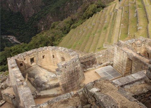
There are several notable buildings within the ruins of Machu Picchu. We have already mentioned the Sun Temple and the Main Gate on the western side. On the eastern side, where the residential buildings are placed, the Incas built a squat tower called the Torreón.

The eastern side of the Torreón.

The purpose of the Torreón has long caused debate amongst Machu Picchu enthusiasts. This enigmatic tower faces due east and contains a doorway on its western side. Inside the tower are possible scorch marks around a rock slab. The tower also features a courtyard with trapezoid insets (which often designates a temple) and there is a cave with carved rock underneath.

As recently as 2011 an enthusiast put forward the theory that Pachacutec was buried at Machu Picchu. The Peruvian Government undertook an excavation in the courtyard behind the tower and a chamber was discovered. As Mark Adams reports, this may have been the tomb of Pachacutec.

Looking down onto the structure. The excavation sight is on the right, covered by plastic roofing.

Looking into the chamber.

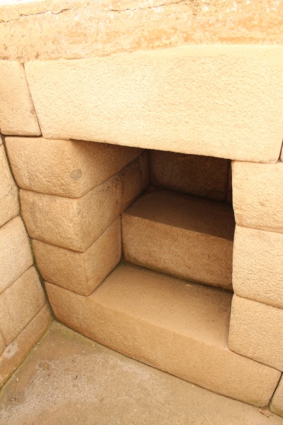
An alcove where possessions would have been stored.

We won't go into the details in a big way but it is also believed that the Torreón housed a gold statue of Pachacutec. This statue was described in Spanish chronicles as part of the empire wide ransom payment to the Spaniards when Atahualpa was captured. It is possible that the statue was fixed here atop a platform, which the Incas burned in order to remove it.

Mark Adams also established that during the winter solstice the sun shines directly through the east facing window, in a perfect line that may have lit up the statue of Pachacutec, if indeed this was where the statue was stored…As we noted above, such design features are unlikely to be coincidences. Perhaps with time there will be consensus but we at least believe the theory that this was the resting place of the Inca empire's greatest Sapa Inca.

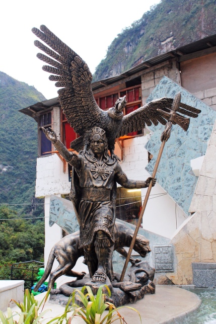
Statue in Aguas Calientes. Note the use of the condor, jaguar and snake.

Hope you enjoyed the post. Machu Picchu was great fun to explore and we highly recommend doing the research before paying a visit. That said, it is still a great time regardless and a good guide can share much, if not all, of what we have covered here.

This is our second-to-last post on the Incas. The last post will share our plans to visit the last city of the Incas, Espiritu Pampa, and the sister site to Machu Picchu, Choquequirao.

Stay tuned,

Mark and Saskia


Pizarro’s Boys Get Their Asses Kicked

History provides a sad record of how the Incas were crushed by Pizarro and his band of merry men, but at Ollantaytambo the Incas had a rare victory. This is the site of an Inca fort, where the Sapa Inca Manco Capac had retreated to face the Spaniards. Manco Capac was Atahualpa's brother, who was installed by the Spanish as a puppet emperor at the age of 17. This proved to be a bad decision. After three years under Spanish occupation he rebelled, starting an uprising across the empire.

Ollantaytambo.

When word got out that the Sapa Inca was fortified at Ollantaytambo the Spaniards resolved to head out and kill him, hoping that with his death the rebellion would end. However, they underestimated how difficult the fort would be. To quote Pedro Pizarro:

“When we arrived we found Ollantaytambo so well fortified that it was a terrifying sight…for the place is very strong, with very high terraces and with very large and well fortified stone walls. It has but one entrance that is against a very steep hill. And…there were many warriors with many boulders, which they had up above to hurl down whenever the Spaniards dared to enter.” – The Last Days of the Incas.

The Spaniards attacked but were repelled by the entrenched Incas. Apparently the amazonian tribes were particularly fierce, raining down razor sharp arrows as the Spaniards charged. The cavalry falted under the stones and arrows and withdrew. With a roar the Incas stormed the plain infront of the fort, the site where the town now stands, to engage the Spaniards directly. Here Manco Capac had devised a cunning plan.

A fine example of Inca masonry.

Steps in the terraces provided short cuts.

The Incas were clever builders. Apparently each Inca was expected to leave buildings behind as a legacy, and this must have helped foster a culture of engineering and architecture. Their achievements included the mastering of aqueducts, which they used to channel water from springs and rivers to towns and fields. Ollantaytambo provides a great example of this, as the aquaducts are still intact and run through the town.

This marvellous piece of stone work can be found within metres of the car park. Note the stone carvings that have been broken off. They would have been serpent, condor or puma heads.

Guttering runs behind the ruins of buildings. This channeled water from a spring to several small basins carved out of the rock.

Manco Capac used these aquaducts to flood the plain when the Spaniards attacked. It effectively bogged down the cavalry, the Spaniards' equivalent of a tank, and forced a retreat. The Incas probably hoped to hold them on the plains and slaughter them all in one go, but the Spanish force was able to escape back to Cuzco.

The valley that was flooded. Note the silos on the opposing cliff face. To the left is what appears to be the face of an old man.

Ollantaytambo was ultimately abandoned by the Incas in the face of a more concerted assault by the Spanish. Manco Capac retreated north west into the wild mountains behind Machu Picchu, where he built the famed last city of the Incas, Espiritu Pampa. Now this is serious Indiana Jones stuff. This was the city that Hiram Bingham originally set out to find, thinking that Machu Picchu was such a place…but we are getting ahead of ourselves.

For now it will suffice to say that Ollantaytambo is a fantistic site to visit. The town has a certain romantic mystique to it and there are plenty of great places to eat and drink. Bear in mind that the tour groups swamp the place in the afternoon, so morning is best. We recommend lunch at Hearts Café and try and grab a huge pisco sour at Ganso.

Local niños.


The Hit List: Cusco and Surrounds

We thought it might be helpful to share our list of places we wanted to visit in and around Cusco. This list was based on reading both Mark Adam's Turn Right at Machu Picchu and Lonely Planet's dedicated 2013 chapter on Cusco.

Cusco City

  • The Museum of Precolombian Art
  • The Inca Museum
  • The Pisco Museum
  • The Cathedral
  • The Cusco Planetarium
  • Qorikancha
  • Sacsayhuaman

Sacred Valley

  • Pisac
  • Ollantaytambo

Huancacalle/Vilcabamba

  • Vitcos*
  • Yurac Rumi*
  • Espiritu Pampa*

Machu Picchu

  • Llactapata*
  • The intihuatana shrine near the hydroelectric station
  • Machu Picchu

Others

  • Choquequirao*

It was an ambitious list but it was only a wish list. Those marked with an asterix were places we were unable to reach. We'll still cover them to explain why they are significant.


¡Six Months!


Day Five: Volcano Hike

We booked an extra day on the salt flats tour to summit Thunupa Volcano. We were hoping to get a better view of the salt lake and to see a second salt lake on the other side of the volcano. It had seemed like a good idea when we booked it but by that stage we were questioning the decision!

So, after a 5:30 am start to watch the sun rise we said good bye to our comrades and headed to Coquesa, a little pre-inca village on the northern edge of the salt flats at the base of Thunupa Volcano.

The view from Coquesa. Note the water.

Thunupa Volcano, peak 5,450 metres.

Around 10:30 am we set out with our guide. It was a long day; we returned at 5:30 pm. As there were no local guides we went with our driver Albierto. He handled it well for someone who sits in a car all day!
The views were spectacular. The sides of the hills were lined with old rock fences, which we could see stretched for some distance. Coquesa is small now and you can see how big it must have been. Now it sits within the ruins of an older civilisation.
The colours of the rock slowly changed to a burnt red as we neared the crater. The air also became thinner. Saskia did well but altitude sickness got the better of her. At around 4,500m she agreed to turn back and find somewhere warm to wait. So Mark and Albierto continued on.

Looking into the crater. You can see the plug near the centre of the pic.

The walk was hard going. The trail crossed loose rock and shingle, which made it difficult to keep our footing. The trail was also steep so the air quickly became thinner and thinner.

Looking down at the southern edge of the crater.

Eventually we reached the rim, which sits at around 4,800 metres. We were pretty relieved to get there. After ten minutes of rest we decided to keep going up. The footing again was uncertain and the air difficult to breath. The trail zig zagged up the side of the rim and Mark found he had to stop and catch his breath at every second turn.
At 5,150 metres we agreed that we were going too slow to reach the summit with the remaining light, let alone be high enough to see down the other side. We were also worried about Saskia waiting for us, so we agreed to turn back. We filmed a panoramic video for Saskia's benefit then raced back down the rim, causing minor rock slides as we slid down the shingle.

We found Saskia well and warm and continued back down. As noted we arrived at the car at 5:30 pm. Our guide had actually left us behind an hour prior and we found him waiting sheepishly in the car. We were too tired to bring it up so jumped in the car and headed back to Coquesa.

Looking south from the feet of Thunupa Volcano.

All in all it was a good time but we were disappointed with being pushed to tackel Thunupa that day. Our understanding was that we would go up on the last day of the trip, which would have given us a whole day plus a bit of rest. Turns out our guide and the cook drive back to Tupiza after dropping people off in Uyuni and their need to get home determined the timing of the hike. So, anyone interested in this hike (which we do recommend) should be crystal clear on which day the hike will be undertaken. Due to the altitude more time makes it much easier so be sure to agree on a schedule that suits you before the tour starts (and make sure that the guide is in that conversation).

Thunupa Volcano from the salt flat.