We booked an extra day on the salt flats tour to summit Thunupa Volcano. We were hoping to get a better view of the salt lake and to see a second salt lake on the other side of the volcano. It had seemed like a good idea when we booked it but by that stage we were questioning the decision!
So, after a 5:30 am start to watch the sun rise we said good bye to our comrades and headed to Coquesa, a little pre-inca village on the northern edge of the salt flats at the base of Thunupa Volcano.

The view from Coquesa. Note the water.

Thunupa Volcano, peak 5,450 metres.
Around 10:30 am we set out with our guide. It was a long day; we returned at 5:30 pm. As there were no local guides we went with our driver Albierto. He handled it well for someone who sits in a car all day!
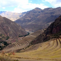
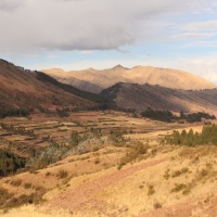
The views were spectacular. The sides of the hills were lined with old rock fences, which we could see stretched for some distance. Coquesa is small now and you can see how big it must have been. Now it sits within the ruins of an older civilisation.
The colours of the rock slowly changed to a burnt red as we neared the crater. The air also became thinner. Saskia did well but altitude sickness got the better of her. At around 4,500m she agreed to turn back and find somewhere warm to wait. So Mark and Albierto continued on.

Looking into the crater. You can see the plug near the centre of the pic.
The walk was hard going. The trail crossed loose rock and shingle, which made it difficult to keep our footing. The trail was also steep so the air quickly became thinner and thinner.

Looking down at the southern edge of the crater.
Eventually we reached the rim, which sits at around 4,800 metres. We were pretty relieved to get there. After ten minutes of rest we decided to keep going up. The footing again was uncertain and the air difficult to breath. The trail zig zagged up the side of the rim and Mark found he had to stop and catch his breath at every second turn.
At 5,150 metres we agreed that we were going too slow to reach the summit with the remaining light, let alone be high enough to see down the other side. We were also worried about Saskia waiting for us, so we agreed to turn back. We filmed a panoramic video for Saskia's benefit then raced back down the rim, causing minor rock slides as we slid down the shingle.
We found Saskia well and warm and continued back down. As noted we arrived at the car at 5:30 pm. Our guide had actually left us behind an hour prior and we found him waiting sheepishly in the car. We were too tired to bring it up so jumped in the car and headed back to Coquesa.

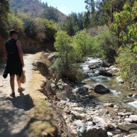
Looking south from the feet of Thunupa Volcano.
All in all it was a good time but we were disappointed with being pushed to tackel Thunupa that day. Our understanding was that we would go up on the last day of the trip, which would have given us a whole day plus a bit of rest. Turns out our guide and the cook drive back to Tupiza after dropping people off in Uyuni and their need to get home determined the timing of the hike. So, anyone interested in this hike (which we do recommend) should be crystal clear on which day the hike will be undertaken. Due to the altitude more time makes it much easier so be sure to agree on a schedule that suits you before the tour starts (and make sure that the guide is in that conversation).

Thunupa Volcano from the salt flat.