¡Ay caramba! Godzilla is on a rampage!

Childhood superheroes to the rescue!
¡Ay caramba! Godzilla is on a rampage!
Childhood superheroes to the rescue!
At the base of Thunupa Volcano is a cave that is home to a family of sacrificed mummies who have been there for over 1200 years. Due to the altitude, the air is dry and cold so the bodies have been well preserved and the cave still contains pottery with remnants of food (quinoa and llama) left with them for the afterlife.


Two small children and the father in the walled off area; mother on the right.

After 1200 years, there is still colour in the pottery and cloth wrapped around the bodies.

One of the older children with offerings of food for the afterlife.

The other older child. If you look closely you can still see colours in the woven cloth.
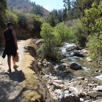
We booked an extra day on the salt flats tour to summit Thunupa Volcano. We were hoping to get a better view of the salt lake and to see a second salt lake on the other side of the volcano. It had seemed like a good idea when we booked it but by that stage we were questioning the decision!
So, after a 5:30 am start to watch the sun rise we said good bye to our comrades and headed to Coquesa, a little pre-inca village on the northern edge of the salt flats at the base of Thunupa Volcano.

The view from Coquesa. Note the water.

Thunupa Volcano, peak 5,450 metres.

Looking into the crater. You can see the plug near the centre of the pic.

Looking down at the southern edge of the crater.

Looking south from the feet of Thunupa Volcano.
All in all it was a good time but we were disappointed with being pushed to tackel Thunupa that day. Our understanding was that we would go up on the last day of the trip, which would have given us a whole day plus a bit of rest. Turns out our guide and the cook drive back to Tupiza after dropping people off in Uyuni and their need to get home determined the timing of the hike. So, anyone interested in this hike (which we do recommend) should be crystal clear on which day the hike will be undertaken. Due to the altitude more time makes it much easier so be sure to agree on a schedule that suits you before the tour starts (and make sure that the guide is in that conversation).

Thunupa Volcano from the salt flat.
We got up early to drive out on to the salt flats to watch the sunrise. It was freezing, but the beautiful colours made up for it. As the sun came up we started to get a sense of just how massive the salt flats are!


After another freezing night in a hotel with no heating or insulation, we got up early to start the day by heading to the Árbol de Piedra (stone tree). Despite the temperature, everyone got out of the jeep and had a look around the rock formations. There were a whole bunch in one little part of a vast expanse of desert, which was quite unusual.


Again, we spent a lot of time driving but had plenty of amazing scenery to stare at out the window. The landscapes kept changing, and even though we drove past another five lakes (Ramaditas, Honda, Chiar Khota, Hedionda, Cañapa), they were all different and equally as beautiful.


Just before dark we arrived at the edge of the Salar de Uyuni (Salt Flats) at a salt hotel which was made entirely from salt. It was still cold, but not quite as cold as the previous two nights, and everyone was excited to have a hot shower (there were no showers in the other hostels).
While we were waiting for dinner to be prepared, Mark went for a walk by himself and came back very excited that he had found puma tracks a few hundred metres from where we were staying. The guides were a little surprised, and we found out afterwards that some people were a litle freaked out at the concept of having big cats so close by (eg. One person got up in the middle of the night to close all the doors and barricade her bedroom door in case the pumas were hungry!)
A couple of the other jeeps from the same company showed up at the same hotel and it was nice to have some extra people to hang out with. We played card games and drank wine to keep warm, which was the perfect way to finish off a great day.


Salt Hotel
We spent a lot of time in the jeep and covered a lot of ground, stopping every now and then to take photos and appreciate the amazing scenery. We passed by several lakes and lagoons which were half frozen and particularly beautiful. A few people tried to walk out on the ice, only to fall through it and end up with wet feet for the rest of the day.
Highlights for the day were the amazing Volcano Licancabur (5950m), swimming in thermal springs in freezing conditions, geysers, and watching the sun set over the pink Laguna Colorada surrounded by flamingoes. The photos speak for themselves, and even then they don't quite do justice to the absolute beauty of the landscapes in this part of the world.


Aguas Calientes (Hot Springs)


Laguna Blanca


Laguna Verde with Volcano Licancabur

Geysers

Laguna Colorada

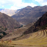
This is another side story from Day Two of The Saga. This wasn't mentioned in the original post but one of our stops was at some 'Haunted Ruins' at the base of a volcano.
The story is that these ruins are pre-Inca. Indigenous people moved here to mine for silver and gold, which eventually attracted the attention of the Incas. The Spanish later came and conquered the site.


The reason it is considered haunted is the town's history of sacrifices. These started off as llama sacrifices in exchange for good luck etc, which in some places is still practiced. The problem is that under the Spanish (? or Inca, we are not clear on this) the sacrifices became human.

Llama bones were scattered around the site.
The village was eventually abandoned and when Bolivia became independent a new colony tried to establish itself (the source of the white washed buildings in the centre of town). Apparently people in the colony suffered nightmares and decided the area was haunted by the ghosts of the human sacrifices. It all became a bit much for the superstitious and they abandoned the site.

The ruins themselves were interesting to walk through but the area was pretty desolate. Mark found various bone piles and even clay jar fragments. We are not sure how old the jar fragments are but the guides seemed genuinely surprised that we found them!

All in all in was an interesting stop. We don't visit sites like this very often!
Howdy,
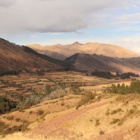
This is a side post from Day Two of “The Saga” (cue dramatic music). As development nerds we were interested in the quality of life of the Bolivians living in Cerillos, one of the small towns we passed through. The following is an attempt to develop a basic profile of Cerillos.
Cerillos is a collection of hamlets located about half a days drive south west of Tupiza via a dirt road. It sits at an altitude of approximately 4,100 metres (we were there in winter and it was dry but freezing cold!). The hamlets have a combined population of around 80 families of between 5 to 10 people each.*

Local shop.
Housing
As you can see in the photo below, the housing is traditional adobe brick with thatch roofing and floors of either dirt, stone or concrete. Apparently it takes 2 to 3 people about 15 days to build a house, which will last 50 years. In this hamlet the houses were designed as walled compounds with stand alone rooms, which they modify based on the family’s needs.

Infrastructure
The town is powered and we saw several sattelite dishes and solar panels, so they definitely keep on top of the football. We’ve already mentioned that the roads are unpaved so they have reasonable access to infrastructure for a remote community. Not many people have access to cars, but there is a steady stream of tourist jeeps and produce trucks passing through.

The nearest hospital is in Tupiza but they have a medical centre in the hamlet. This is staffed by a doctor and two nurses. We don’t know what their level of training is and we did not visit the centre.
Local diet is fairly basic and consists of llama, beans, quinoa, maize and of course potatoes.
With regard to water they are apparently quite secure; we were told there is sufficient water all year round, with rains coming in summer. Water is accessed via a large pump and pipe system which draws from an underground source. We are not experts on this sort of thing but as you can see below the system is sophisticated.

The sanitation situation will make many squirm. The little we saw was not good. As there were no toilets in the café we were all forced to ‘use nature’. When searching for a good spot we did find two outdoor toilets near a school. They had three walls, a concrete floor and a roof. However, there was no door, toilet base or hole in the floor, let alone a ventilation pipe. We’ll spare you a description of the mess but it was revolting. Hate to think that kids have got to use those facilities.
Solid waste was dumped in a gully by the school. Not sure what their options are in that environment but this is more or less what we expected (although we didn’t like it being so close to the school).

Taken from a different village but you get the idea.
Education
They do have a school which services all the hamlets. Disappointed to admit that we forgot to ask any questions on this. You might be interested to know that kids typically attend school for half a day as they are also expected to assist their families with manual labour. We also note that secondary school only became compulsory in 2010.
Income
As we understood it the mines in the area were the main source of income. This is where most of the men worked. Household income was supplemented by the sale of llama meat and pelts. Apparently the women tendered the llama herds if the men worked in the mines.
As the climate there is so arid there are poor options for food crops. So, it seems that the people of Cerillos are very much dependent on the success or failure of the mines.


Pen of llamas with colourful earrings to mark ownership in the village.
Pros and Cons
Reading back over the post, we are surprised at the amount of information we have. Although it is only a basic outline, we thought that the village was well served in terms of services and access to infrastructure. Bear in mind that this is a remote community in South America’s poorest country. We think that the community is fairly self-sufficient, a good thing if people wish to preserve the village way of life.
There are a few issues though. We haven’t delved into the mining situation but with only two sources of income the village’s economic security is tied to the mines. We wouldn’t be surprised if most of the villagers emigrated once the money begins to dry up. That said, the mines probably instigated the village’s creation.
The environmental sanitation was not good. Those are the worst toilets we have ever seen and the solid waste was an ugly pile of trash. This stuff often gets neglected (1 billion people still defecate in the open) but it is a shame to see things like this. We later saw that things were better managed in other communities.

Abandoned house on the outskirts of a village.
Wrap Up
So, hopefully this was interesting to read. It was certainly fun to write, not bad for a spur of the moment idea. But that’s all it was…Please note that Bolivian villages are not homogenous. The climate, the proximity to urban centres and trunk roads are just some of the factors that can make a big difference between village life in different parts of Bolivia. This was just an attempt to provide a snapshot of what life is like in a village we visited. Hopefully it has been informative.
Thanks for reading,
Mark and Saskia.
*We didn’t ask about maternal or child health, although we should have given the family size. We mostly spoke to our guide and assumed there is only so much he could know. Here are some national stats that may be of interest:
After looking into our options, we organised our trip with Tupiza Tours. We left early in the morning in a convoy of four jeeps, each loaded with food, water and fuel. We had to be self-sufficient as our accommodation was very basic. So, in our car we had our guide (Alberto) as well as a cook (Veronica) and we were joined by Claire from Ireland and Tyler from Canada.

The crew. Pic taken near Palala Village.
We started out by covering the same ground as the previous day's mountainbike ride to El Sillar. This time we visited the top of the ridge, which gave us a great view on either side.

Looking down to the Rio San Juan del Oro.


That was a long night and it was the coldest on the tour.
Crossing the border from Argentina was relatively straight forward. We caught a bus from Tilcara to La Quiaca, walked a few kilometres, then got our stamps and crossed into Villazón. From there we jumped straight into an overcrowded mini van with a crazy driver who delivered us safely to Tupiza. The town itself is nothing special, but the surrounding landscape is exceptional!

Most people seem to stop over quickly in Tupiza on their way to the Salt Flats, but we wanted to get to know the countryside a little better so we stayed for a few days. One activity offered is the Triathlon, which involves a combination of a 4x4WD jeep tour, horse riding and mountain biking. We decided that this was the best way to cover the area in a short amount of time and have a bit of fun along the way!